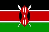
Official Name: Republic of KenyaCapital: NairobiTotal Area: 224,962.42 sq mi ~ 582,650.00 sq km
(About twice the size of Nevada)Population: 31,339,770 ( est.)Tribes:
22% Kikuyu, 14% Luhya, 13% Luo, 12% Kalenjin, 11% Kamba, 6% Kisii, 6% MeruLanguages:
English (official), Kiswahili (official), numerous indigenous languagesReligions:
Protestant 38%, Roman Catholic 28%, indigenous beliefs 26%, Muslim 7%, other 1%Currency:
1 Kenyan shilling (Ksh) = 100 centsExchange rate: Ksh 78 to One Dollar US (June 2002)
GDP (per capita): $1,600 (1999 est.)Labor Force (by occupation)
Agriculture 75%-80%Industry:
Small-scale consumer goods (plastic, furniture, batteries, textiles, soap, cigarettes, flour), agricultural products processing; oil refining, cement; tourismAgriculture:
Coffee, Tea, Corn, Wheat, Sugarcane, Fruit, Vegetables; Dairy Products, Beef, Pork, Poultry, Eggs
Arable Land: 7%Exports:
Tea, Coffee, Horticultural Products, Petroleum Products (1995)Imports:
Machinery and Transportation Equipment, Petroleum Products, Iron and Steel
Natural Resources: Gold, Limestone, Soda Ash, Salt Barites, Rubies, Fluorspar, Garnets, Wildlife, HydropowerIndependence:
12 December 1963 (from UK)National holiday:
Independence Day, 12 December (1963)Constitution:
12 December 1963; amended as a republic 1964; reissued with amendments 1979, 1982, 1986, 1988, 1991, 1992, 1997, and 2001Location:
Eastern Africa, bordering the Indian Ocean, between Somalia and TanzaniaGeographic coordinates:
1 00 N, 38 00 EArea:
total: 582,650 sq km
land: 569,250 sq km
water: 13,400 sq kmLand boundaries:
total: 3,477 km
border countries: Ethiopia 861 km, Somalia 682 km, Sudan 232 km, Tanzania 769 km, Uganda 933 kmCoastline:
536 kmMaritime claims:
territorial sea: 12 nm
exclusive economic zone: 200 nm
continental shelf: 200-m depth or to the depth of exploitationTerrain:
low plains rise to central highlands bisected by Great Rift Valley;
fertile plateau in westElevation extremes:
lowest point: Indian Ocean 0 m
highest point: Mount Kenya 5,199 mNatural resources:
limestone, soda ash, salt, gemstones, fluorspar, zinc, diatomite, gypsum, wildlife, hydropowerLand use:
arable land: 8.08%
permanent crops: 0.98%
other: 90.94% (2001)
Irrigated land:
670 sq km (1998 est.)I made this slideshow at FreeFlashSlideshow.com .
Check out these MySpace Slideshows !
