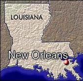
The state is bordered to the west by the state of Texas; to the north by Arkansas; to the east by the state of Mississippi; and to the south by the Gulf of Mexico.The surface of the state may properly be divided into two parts, the uplands, and the alluvial and coast and swamp regions. The alluvial regions, including the low swamps and coast lands, cover an area of about 20,000 square miles (52,000 km2); they lie principally along the Mississippi River, which traverses the state from north to south for a distance of about 600 miles (1000 km) and ultimately emptying into the Gulf of Mexico, the Red River, the Ouachita River and its branches, and other minor streams.
*New Orleans
The breadth of the alluvial region along the Mississippi is from 10 to 60 miles (15 to 100 km), and along the other streams it averages about 10 miles (15 km). The Mississippi flows upon a ridge formed by its own deposits, from which the lands incline toward the low swamps beyond at an average fall of six feet per mile (3 m/km). The lands along other streams present very similar features. These alluvial lands are never inundated save when breaks occur in the levees by which they are protected against the floods of the Mississippi and its tributaries. These floods, however, do not occur annually, and they may be said to be exceptional. With the maintenance of strong levees these alluvial lands would enjoy perpetual immunity from inundation.
*Baton Rouge
The uplands and contiguous hill lands have an area of more than 25,000 square miles (65,000 km2), and they consist of prairie and woodlands. The elevations above sea-level range from 10 feet (3 m) at the coast and swamp lands to 50 and 60 feet (15-18 m) at the prairie and alluvial lands. In the uplands and hills the elevations rise to Driskill Mountain the highest point in the state at only 535 feet (163 m) above sea level, located in northwest Louisiana.
*Shreveport
Besides the navigable rivers already named (some of which are called bayous), there are the Sabine, forming the western boundary, and the Pearl, the eastern boundary, the Calcasieu, the Mermentau, the Vermilion, the Teche, the Atchafalaya, the Boeuf, the Lafourche, the Courtableau, the D'Arbonne, the Macon, the Tensas, the Amite, the Tchefuncte, the Tickfaw, the Natalbany, and a number of other streams of lesser note, constituting a natural system of navigable waterways, aggregating over 4,000 miles in length, which is unequalled in the United States. The state also has 1,060 square miles (2,745 km2) of land-locked bays, 1,700 square miles (4,400 km2) of inland lakes, and a river surface of over 500 square miles (1300 km2).Click Me - National Parks ServiceBEGINMYSPACETOOLBOXBACKUP VERSION 1.0;;111111; http://img166.imageshack.us/img166/7318/neworleans1qm8.jpg; Center Center; fixed; no-repeat; ffffff; ; bold; ; ; italic; ; ff0000; 10pt; bold; ; ; ; ; ff0000; ; bold; ; ; ; ; 0099ff; ; bold; ; ; ; Comic Sans, Comic Sans MS, Cursive; 000000; http://c.myspace.com/Groups/00007/99/15/7775199_m.gif; Center Center; scroll; repeat; cccccc; solid; 3px;;ENDMYSPACETOOLBOXBACKUP
Try the BEST MySpace Editor at MySpace Toolbox !
